
attraction · Cádiz
Ruinas del Fuerte de Santa Bárbara
Andalucía 365 · Updated 18 July 2026
Our Verdict
“A historically significant but visually modest ruined fort that explains the geopolitical origins of La Línea de la Concepción.”
Last verified: July 2026
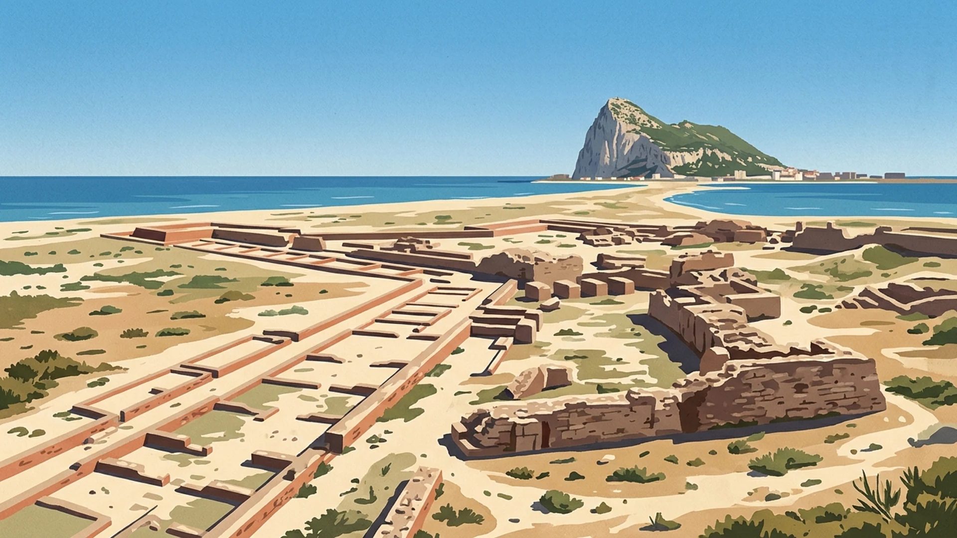
The Ruinas del Fuerte de Santa Bárbara stand on the eastern shoreline of La Línea de la Concepción, marking the physical and historical origins of the municipality. Constructed in the 1730s by military engineer Jorge Próspero de Verboom under the orders of King Felipe V, this fortification was the eastern anchor of the Línea de Contravalación. This formidable defensive wall was built to contain British expansion after the loss of Gibraltar in 1704. Blown up by British sappers in 1810 to prevent its capture by advancing Napoleonic troops, the site survives today as an open-air archaeological footprint. It appeals to military history enthusiasts and visitors seeking to understand the complex geopolitical borderlands of the Campo de Gibraltar. Recent municipal works are transforming the ruins into an accessible interpretation space alongside the Mediterranean Sea.
The Origins of a Border Town
The history of La Línea de la Concepción is inextricably linked to the stones of the Ruinas del Fuerte de Santa Bárbara. Following the capture of Gibraltar by an Anglo-Dutch fleet in 1704 and its subsequent formal cession to Great Britain under the 1713 Treaty of Utrecht, the Spanish Crown faced a new strategic reality. To prevent further British territorial expansion northwards into the Iberian Peninsula, King Felipe V ordered the construction of a massive defensive barrier across the sandy isthmus. This structure became known as the Línea de Contravalación, a continuous fortified wall stretching from the Mediterranean Sea to the Bay of Algeciras. The civilian settlement that eventually grew behind this military boundary took its very name from the fortification line, evolving from a temporary camp for soldiers and tradespeople into a permanent municipality.
Engineering the Contravalación
Designed by the prominent military engineer Jorge Próspero de Verboom, the defensive line was completed between 1730 and 1735. The Ruinas del Fuerte de Santa Bárbara formed the eastern anchor of this system, situated directly on the Mediterranean beach known as Playa de Levante. At its operational peak, the fort was a formidable military installation designed to project power across the neutral ground. Its defensive capabilities included:
- 18 heavy cannons of 24-pound calibre
- Six howitzers for high-angle bombardment
- Four barracks accommodating grenadiers, cavalry and artillerymen
- A deep defensive moat designed to thwart infantry assaults
The western end of the line was secured by the Fuerte de San Felipe, with a series of smaller bastions connecting the two main fortresses across the flat terrain.
The 1810 Demolition
The operational life of the fort ended abruptly during the Peninsular War. In 1810, as French Napoleonic forces advanced through southern Spain and the wider Cádiz province, a temporary alliance existed between Spain and Great Britain. Fearing that the formidable Línea de Contravalación would fall into French hands and be used to besiege Gibraltar from the landward side, British sappers systematically blew up the fortifications. This preemptive destruction, carried out with the reluctant agreement of the Spanish authorities, reduced the Fuerte de Santa Bárbara to rubble. For over a century, the site remained abandoned. Its dressed stones were often repurposed by local residents for civilian construction, until initial military recovery efforts began in the late 1970s to excavate the buried foundations.
Current Municipal Works and Access
Today, the site is undergoing a significant transformation. The local council initiated a major conditioning project in late 2025 to convert the ruins into a formal open-air archaeological park. These ongoing works involve clearing the original moat of accumulated sand and debris, installing safe pedestrian walkways and establishing an interpretation centre to explain the military architecture. As part of this reorganisation, stones belonging to the western Fuerte de San Felipe, which had been temporarily stored at the Santa Bárbara site, are being relocated to a dedicated public park nearby. Visitors should anticipate that access routes and interpretation panels will evolve as these municipal improvements progress. The site remains an open, exposed area directly adjacent to the beach promenade, offering clear sightlines towards the Rock of Gibraltar.
Our verdict
The Ruinas del Fuerte de Santa Bárbara require a degree of imagination from the visitor. This is not a towering, intact castle, but rather a ground-level footprint of foundations, partial walls and excavated moats. For those with a casual interest in architecture, the visual impact may be modest compared to other fortresses in the region. However, for anyone exploring the military history of the Campo de Gibraltar, the site is fundamental. It provides the physical context needed to understand the origins of the municipality and the enduring geopolitical tensions of the border. The current municipal works are a welcome intervention that will eventually make the complex history much easier to digest. Until the interpretation centre is fully operational, reading about the site beforehand is highly recommended to appreciate the scale of Verboom's original design.
Practical Information
The ruins are located at the eastern end of the Avenida del Ejército, right next to the Playa de Levante and the municipal stadium. As an open-air coastal site, it is entirely exposed to the elements. The location means it is frequently subjected to strong Levante winds blowing off the Mediterranean Sea, and there is absolutely no shade available during the summer months. Early morning or late afternoon visits are advisable in July and August to avoid the intense midday heat.
Mobility access is currently mixed. While the surrounding promenade is flat and paved, navigating the actual ruins involves uneven ground, sandy patches and loose stones. The new walkways planned in the municipal works aim to resolve these accessibility issues, but wheelchair users may find the interior of the site challenging until the project is completed. Parking is generally available in the streets surrounding the stadium, though spaces fill up quickly on match days or during the peak summer beach season. For the most current information on the progress of the archaeological park and visitor access, consult the official heritage catalogue.
Nearby worth your time
A few well-placed stops for extending the day without turning it into a checklist.
Continue through Campo de Gibraltar
Step back into the wider landscape with local guides, nearby places and the province overview.
Place guide · 7 min
Playa de La Caleta: A Guide to the Historic Heart of Cádiz
Playa de La Caleta is a historic urban bay in Cádiz, famous for its calm waters, ancient fortresses, and the stunning white Balneario spa building.
Place guide · 7 min
Playa de los Caños de Meca: A Guide to the Cádiz Coastline
Discover the wild Atlantic beauty of Playa de los Caños de Meca, from its freshwater springs to the historic Cape Trafalgar lighthouse.
Itinerary · 7 min
Three Days in Cadiz: The Ultimate Itinerary for Independent Travellers
Three days allows you to completely sink into the maritime rhythm of Europe's oldest city. You can cover the historic centre, explore the twin seaside fortresses, and still have time for a sherry tasting afternoon across the bay.